
Free online viewing of over 45,000 BGS maps and sections
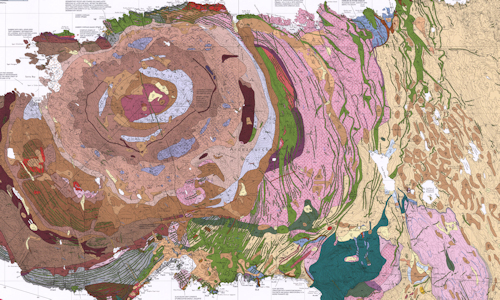
1:25 000 Classical areas sheet 51
The collections provided here include:
- 6,000 medium and small scale published maps. Almost all BGS published maps are available including 1:63,360/1:50,000 and smaller scales geological mapping; as well as our collections of geological sections, geophysical, geochemical and hydrogeological maps.
- 39,000 1:10,560/1:10,000 geological maps. Most maps are manuscript, or fair drawn. A small percentage, mostly from coalfield areas were issued as published sheets. Please note that these maps can be extremely variable in format and content.
The Maps Portal provides access to view BGS maps, with the option to purchase high-resolution raster PDFs via the BGS online shop.
All users are advised that our latest digital mapping is available to view via our Onshore and Offshore GeoIndex pages, and may differ significantly from the maps delivered via this portal. Further details about our digital vector data mapping is available via BGS Datasets.
Alternatively, users can request this data via GeoReports, or our Custom 1:50 000 Geological Maps services.
Send us your feedback about the new Maps Portal
- Maps & sections
- Index to colours
- About & history
About the colours used on geological maps
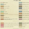 Index to colours used on geological maps
Charts to indicate the colours used for hand-colouring the different strata on the maps and sections. It is interesting to view the changes over time.
Index to colours used on geological maps
Charts to indicate the colours used for hand-colouring the different strata on the maps and sections. It is interesting to view the changes over time.
About the maps portal and historical information
 About this site
The scope of the site is described, what map series are included and what are excluded. Includes brief notes on navigating and using the Maps portal.
About this site
The scope of the site is described, what map series are included and what are excluded. Includes brief notes on navigating and using the Maps portal.
 Introduction to BGS 1:10 560 / 1:10 000 mapping
Important contextual information about the production of BGS 1:10560/1:10000 paper geological maps and field slips.
Introduction to BGS 1:10 560 / 1:10 000 mapping
Important contextual information about the production of BGS 1:10560/1:10000 paper geological maps and field slips.
The BGS 1:10 560 / 1:10 000 geological maps are a very complex series. Users are strongly advised to read the accompanying notes.
 Geological Survey of Great Britain & Ireland 1:63 360 scale geological maps and sections — historical notes
Brief historical notes and links to key documents on the early 1:63 360 map series for England and Wales, Scotland and Ireland.
Geological Survey of Great Britain & Ireland 1:63 360 scale geological maps and sections — historical notes
Brief historical notes and links to key documents on the early 1:63 360 map series for England and Wales, Scotland and Ireland.
 The origins of systematic geological mapping in Britain
An insight into the origin and early practice of systematic geological mapping by the Geological Survey; the application of hand-colouring; why the constant need for revision?
The origins of systematic geological mapping in Britain
An insight into the origin and early practice of systematic geological mapping by the Geological Survey; the application of hand-colouring; why the constant need for revision?
Terms of use
To encourage the use and re-use of these maps we have wherever possible made them available under the Open Government Licence, subject to the following acknowledgement accompanying the reproduced BGS materials: "Contains British Geological Survey materials © UKRI [year]".
Some maps contain Ordnance Survey copyright. Maps produced by the Ordnance Survey are covered by Crown Copyright which is 50 years. For example, Crown Copyright on a map published in December 1972 would usually pass out of copyright in January 2023. Please check the OS Copyright Date on the individual map and if it is within copyright, please note the following terms and conditions:
- You are granted a non-exclusive, royalty free revocable licence solely to view the licensed data for non-commercial purposes for the period during which the British Geological Survey makes it available;
- You are not permitted to copy, sub-license, distribute, sell or otherwise make available the Licensed Data to third parties in any form; and
- Third party rights to enforce the terms of this licence shall be reserved to Ordnance Survey. © Crown copyright and database rights [year] Ordnance Survey AC0000824781.
Please be aware that separate terms will be supplied with digital or hard copy versions of the map purchased via the BGS Bookshop.
If you have any questions regarding the above please contact ipr@bgs.ac.uk